LETKF-based Ocean Research Analysis (LORA)
- DOI: 10.57746/EO.01hc1e0qpr8z5jmn7cnwwrf3j5
- Last Updated: 2025-01-31
Product Summary
JAXA and RIKEN aim to unify satellite data (AMSR2, Himawari, etc.) and ocean simulation and create an ensemble ocean analysis product, LETKF-based Ocean Research Analysis (LORA), by assimilating satellite and in-situ observations from JAXA and various institutions at a 1-day interval in a high-resolution regional ocean data assimilation system, sbPOM-LETKF, developed by RIKEN. LORA has the advantages of 1) being a three-dimensional gridded dataset without missing values, 2) having high accuracy especially in the mid-latitude regions, and 3) quantifying uncertainty. The uncertainty is estimated from the standard deviation of 128 ensemble members (i.e., ensemble spread). In addition to the daily averaged ensemble mean and spread of basic variables, LORA provides daily-averaged all ensemble members at the sea surface and ensemble mean of each term in mixed-layer temperature and salinity budget equations, respectively, to be utilized for boundary conditions in atmospheric models and for quantitative analyses of spatiotemporal variations in sea surface temperatures and salinity.
-----------------------------------------------
Version, Release date, Availability
-----------------------------------------------
Ver.1.0, 2023-3-31, Available
- Platform
- Model
- Sensor
- N/A
Coverage
Temporal Coverage
2015-08-01 to 2024-01-31
Spatial Coverage
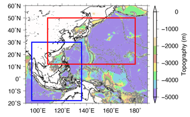
Bounding Rectangle
WNP (red) (50.0°, 108.0°, 12.0°, 180.0°)
MC (blue) (30.0°, 95.0°, -18.0°, 136.0°)
Resolution
0.1 degree
Location
- NORTHWEST PACIFIC OCEAN, WESTERN PACIFIC OCEAN
- Dataset Short Name
- LETKF-based_Ocean_Research_Analysis_(LORA)
- Platform / Sensor
- Model / N/A
- Coverage
-
- Spatial Coverage
-
Bounding Rectangle
WNP (Western North Pacific) (50.0°, 108.0°, 12.0°, 180.0°),
MC (Maritime Continent) (30.0°, 95.0°, -18.0°, 136.0°) - Temporal Coverage
- 2015-08-01 to 2024-01-31
- Product Level ID
- L4
- Version Description
Ver.1.0
- File Format
- NetCDF
- Dataset Type
- Daily average / frame
- Resolution
-
- Spatial Resolution
- 0.1 degree
- Temporal Resolution
- Daily
- Dataset Progress
- In Work
- Projection
- Equal Latitude-Longitude grid (Arakawa-C)
- Collection Data Type
- SCIENCE_QUALITY
- Get Data
- https://www.eorc.jaxa.jp/ptree/LORA/index.html
- Dataset Title
- LETKF-based Ocean Research Analysis (LORA)
- Distribution Format
- NetCDF
- Fees
- Free
- Citation
- Ohishi et al., 2024: https://doi.org/10.1002/gdj3.271
Ohishi et al., 2023: https://link.springer.com/article/10.1007/s10236-023-01541-3
Japan Aerospace Exploration Agency, 2015: LETKF-based Ocean Research Analysis (LORA). https://doi.org/10.57746/EO.01hc1e0qpr8z5jmn7cnwwrf3j5 - Access Constraints
Use of the data provided by this system is limited to non-profit purposes such as research and education. Users need to register at the JAXA Himawari Monitor (https://www.eorc.jaxa.jp/ptree/registration_top.html) to get account for downloading.
- Use Constraints
Users cannot redistribute the data to the third parties. Conditions of data use are described in registration page (https://www.eorc.jaxa.jp/ptree/registration_top.html) and Section 3 “Reporting requirement” of User Guide (https://www.eorc.jaxa.jp/ptree/userguide.html). Users should specify the following sentence when they publish a thesis, a report, and so on by using the dataset. “Ocean model product that was used in this paper was jointly developed by the Japan Aerospace Exploration Agency (JAXA) and RIKEN and supplied by the JAXA P-Tree System.”
- P-Tree Terms of service
- https://www.eorc.jaxa.jp/ptree/registration_top.html
- ISO Topic Categories
-
- OCEANS
- Science Keywords
-
- EARTH SCIENCE > OCEANS
- EARTH SCIENCE SERVICES > MODELS > OCEAN GENERAL CIRCULATION MODELS (OGCM)/REGIONAL OCEAN MODELS
- Location Keywords
-
- GEOGRAPHIC REGION > OCEAN > PACIFIC OCEAN > NORTHWEST PACIFIC OCEAN, WESTERN PACIFIC OCEAN
- ECV and other Keywords
-
- ocean temperature
- salinity
- current
ISO Topic Categories is the keywords in the ISO 19115 - Geographic Information Metadata.
Science Keywords hosts Global Change Master Directory (GCMD) Keywords which are a hierarchical set of controlled Earth Science vocabularies that help ensure Earth science data, services, and variables are described in a consistent and comprehensive manner and allow for the precise searching of metadata and subsequent retrieval of data, services, and variables.
ECV Keywords hosts a physical, chemical or biological variable or a group of linked variables that critically contributes to the characterization of Earth's climate.