Catalog Services for the Web (CSW)
Standards
Endpoint URL
Collection search
https://gpwos1.jaxa.jp
example
https://gpwos1.jaxa.jp/examind/api/WS/csw/preview/opensearch?service=CSW&version=3.0.0&q=sst
Granule search
https://gportal.jaxa.jp
saample
https://gportal.jaxa.jp/csw/csw?service=CSW&version=3.0.0&request=GetRecords&outputFormat=application/atom+xml&datasetId=10002002&startTime=2021-07-07T00:00:00Z&endTime=2021-07-07T11:59:59Z&bbox=130,40,140,30
2 step search
Two catalog search services are available: "for collection" and "for granule".
Search collections by Collection search(https://gpwos1.jaxa.jp).
Retrieve the Open Search Description Document (OSDD) from the result of the collection search.
Retrieve the download URL that corresponds to OSDD.
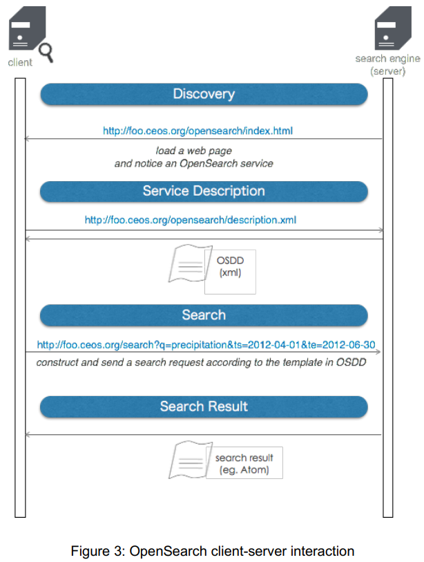
Image from CEOS OpenSearch Best Practice.
collection search (gpwos1.jaxa.jp)
open search description is available here.
url template
parameter |
necesary |
description |
value |
|---|---|---|---|
service |
required |
fixed |
CSW |
version |
required |
fixed |
3.0.0 |
q |
required |
Textual search in the title, abstract of keyword section of the metadata. Surround with double quotes for exact match. |
stringex)sst |
maxRecords |
optional |
Number of results returned per page (default 10) |
integer ex)1000 |
startPosition |
optional |
The starting number for the display |
integerex)1 |
bbox |
optional |
Region of Interest defined by 'west, south, east, north' coordinates of longitude, latitude, in decimal degrees (EPSG:4326). |
west, south, east, northex)130,30,140,40 |
recordIds |
optional |
Metadata identifier |
see Dataset Short Nameex)GCOM-W_AMSR2_L2_SST |
geometry |
optional |
Region of Interest defined in Well Known Text standard (WKT) with coordinates in decimal degrees (EPSG:4326) |
|
relation |
optional |
The spatial operator to apply using the value of the geometry parameter. (default value: Intersects) |
EqualsDisjointTouchesWithinOverlapsCrossesIntersectsContainsDWithinBeyond |
lat |
optional |
Latitude expressed in decimal degrees (EPSG:4326) - should be used with geo:lon |
integer(-90~90)ex)40 |
lon |
optional |
Longitude expressed in decimal degrees (EPSG:4326) - should be used with geo:lat |
integer(-180~180)ex)130 |
radius |
optional |
Expressed in meters - should be used with geo:lon and geo:lat |
|
name |
optional |
Location string e.g. Paris, France |
ex)Pris |
startDate |
optional |
Start date to be compared with the data acquisition time. |
ex)2018-01-01T00:00:00Z |
endDate |
optional |
End date to be compared with the data acquisition time. |
|
trelation |
optional |
The temporal operator to apply using the value of the time parameter. (default value: TEquals for single date, AnyInteracts for period) |
AfterBeforeBeginsBegunByTContainsDuringEndedByEndsTEqualsMeetsMetByTOverlapsOverlappedByAnyInteracts |
outputSchema |
optional |
Used to indicate the schema of the output that is generated in response to a GetRecords request. |
http://www.opengis.net/cat/csw/3.0http://www.isotc211.org/2005/gmdhttp://www.opengis.net/cat/csw/2.0.2http://www.isotc211.org/2005/gfchttp://gcmd.gsfc.nasa.gov/Aboutus/xml/dif/ |
example
curl -skL "https://gpwos1.jaxa.jp/examind/api/WS/csw/preview/opensearch?service=CSW&version=3.0.0&q=sst"
granule search (gportal.jaxa.jp)
parameter |
necesary |
description |
value |
|---|---|---|---|
service |
required |
fixed |
CSW |
version |
required |
fixed |
3.0.0 |
request |
required |
fixed |
GetRecords |
datasetId |
optional |
Dataset ID |
see Dataset ID table |
id |
optional |
identifier |
granule_idex)ALOS2146782480-170209 |
bbox |
optional |
egion of Interest defined by 'west, south, east, north' coordinates of longitude, latitude, in decimal degrees (EPSG:4326). |
west, south, east, northex)130,30,140,40 |
updateTime |
optional |
The update's date and time. |
yyyy-mm-ddTHH:MM:SSex)2021-04-28T17:00:00 |
Pseq |
optional |
polar stereo |
ex)EQ |
aqtype |
optional |
acquisitionType |
ex)NOMINAL |
deg |
optional |
imageQualityDegradation |
ex)0 |
psdate |
optional |
processingDate |
ex)2021-04-28T17:30:00 |
pslv |
optional |
processingLevel |
ex)L1A |
startTime |
optional |
beginPosition |
ex)2021-04-28T18:00:00 |
endTime |
optional |
endPosition |
ex)2021-04-28T18:30:00 |
sat |
optional |
satelliteName |
ex)GCOM-C |
sen |
optional |
sensorName |
ex)SGLI |
operationalMode |
optional |
operationalMode |
ex)NOMINAL |
pathno |
optional |
wrsLongitudeGrid |
ex)240 |
rowno |
optional |
wrsLatitudeGrid |
ex)253 |
orbitno |
optional |
orbitNumber |
ex)3044 |
lastorbitno |
optional |
lastOrbitNumber |
ex)679 |
pointingAngle |
optional |
acrossTrackIncidenceAngle |
ex)0 |
polarisation |
optional |
polarisationChannels |
ex)HH |
daynight |
optional |
daynight |
ex)Night |
prdver |
optional |
version |
ex)05A |
cloud |
optional |
cloudCoverPercentage |
ex)0 |
quality |
optional |
totalQualityCode |
ex)Good |
physicalQuantity |
optional |
physicalQuantity |
ex)AGB |
resolution |
optional |
Resolution |
ex)1km |
numberMissingData |
optional |
numberMissingData |
ex)0 |
sceneNumber |
optional |
sceneNumber |
ex)17 |
orbitDirection |
optional |
orbitDirection |
ex)Descending |
tileHNo |
optional |
tileHNo |
ex)19 |
tileVNo |
optional |
tileVNo |
ex)10 |
tiltSegmentNumber |
optional |
tiltSegmentNumber |
ex)1 |
RSPPathNumber |
optional |
RSPPathNumber |
ex)232 |
sensorNumber |
optional |
sensorNumber |
ex)1 |
offNadir |
optional |
offNadirAngle |
ex)32.4 |
orbitStatus |
optional |
orbitStatus |
ex)H |
ProcessTimeUnit |
optional |
ProcessTimeUnit |
ex)01D |
example
curl -skL "https://gportal.jaxa.jp/csw/csw?service=CSW&version=3.0.0&request=GetRecords&outputFormat=application/atom+xml&datasetId=10002002&startTime=2021-07-07T00:00:00Z&endTime=2021-07-07T11:59:59Z&bbox=130,40,140,30"